Sunday, March 26, 2006

It was forty years ago today...

...that the Rolling Stones played a venue known as Brabanthal in Den Bosch, Netherlands. And I was there. This was my first big rock event. The Stones had made a name for themselves over the previous couple of years and their lone previous appearance in the Hague (Scheveningen) had ended in a major riot where the 'audience' destroyed the concert hall. So this sounded like fun. That day (March 26th) was my birthday (still is, as a matter of fact). My brother Gerard had been able to somehow obtain 4 tickets for this concert and was kind enough to invite me along. He had, under false pretenses I might add, also been able to borrow a Volkswagen Beetle off some guy he knew at work. Not that the car was an absolute necessity, but it sure made getting there a lot easier than having to take public transit to Den Bosch as it was about 100 km away. So off we drove, late in the afternoon, the 4 of us squeezed into the bug. The venue was normally used to auction cattle, so since the place was already a pigstye, I guess the organizers figured this was the ideal place for a rock concert. Not that the word concert was actually used for an event like that back in those days: that term was strictly reserved for classical music events. To call a performance by the Stones a concert would have been sheer blasphemy. Total number of spectators was extremely low as well: 9000. The entrance fee was pretty steep though: 10 guilders, which converted to about $3 US back in 1966. 
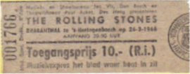
The warm up acts were Dutch groups, among them the Outsiders and the Bintangs, both now revered in Dutch pop history. The late Wally Tax was the leader of the Outsiders, and a legend in his own mind even back then. I remember we made our way in through some kind of small side entrance. The hall was already packed and the concert was in progress. There were no seats, everybody just sort of piled up against the stage. Talking about the stage, it wasn't exactly up to today's standards: very few, if any spotlights, no massive amplifier banks and speakers. The only fireworks would have been Keif smoking on stage. Mick was his usual trade mark self. From the setlist I don't remember much: the only thing that comes to mind is '19th Nervous Breakdown', the end riff where Bill Wyman's bass sonically mimics a person slide into a state of mental anguish.

The next time I saw the boys live was at Sarsstock in Toronto in 2003, 37 years later. Number of spectators: 500,000.


Tuesday, March 21, 2006

Thank you, vandals...

...for if it wasn't for your destructive behaviour I never would have found out about the Waterford Heritage Rail Trail. You see, some time ago there was a report in the local newspaper about some fences being destroyed on this trail. So, with a little bit of sleuthing, we found out where the trail runs. Turns out it is just about under our nose, well, say 6 km directly east of us, just east of Hwy 24 on Townsend Road #12.

Today, we decided to take it for a test spin. And it's certainly worth exploring. It runs through, as the brochure describes it, a 'pastoral' landscape, consisting of about 60% farmer's fields and the rest bush and thickets. As luck would have it, just 20 minutes into our walk, three deer appeared from behind a low hill to our right. We looked at them, they looked at us, then off they ran, white tails being waved like fans on a summer's day.

The trail is around 6.2 km in length, of which we did the top 4 return. In addition to that, we walked into Waterford and had a coffee/tea in "The Cafe".

Then, on a sidestreet in Waterford, I spotted this door. Seems like the contractor miscalculated the depth of the basement.


Waterford Heritage Trail
Even though the temperature was right around zero again, at times, it felt a lot warmer than that when the sun was out. Could it be true? Is spring really on its way? Nah, don't get too excited.

Monday, March 20, 2006

The answer, my friend, is blowin' in the wind

The new face of Norfolk CountyAlong the northern shoreline of Lake Erie, east of the sleepy little fishing town of Port Burwell, contractors are currently constructing 66 wind turbines. Each of these turbines is capable of generating 1.5 MW (megawatts), so the total project's potential is 99 MW, enough to power 30,000 homes. As a comparison, Toronto's lone Exhibition Place generator is capable of producing .75 MW, enough for 250 homes.

Since this project is now in its advanced stages, we decided today to take a field trip out to


Turbine 52, just west of Houghton Centre, south of Lakeshore Roadthe site, approximately 50 km to the southwest of where we are. The weather was partly cloudy, with the temperature hovering around zero degrees celsius, a little cool for this time of year, but not too bad.

The turbines aren't hard to find, just drive in the general direction and sooner or later they will pop out above the tree line. Then just home in. If you miss them, you'll find yourself swimming in Lake Erie.

Now I must say, these things are humongous. Not only that,
they


are very big. Produced by GE (General Electric), they are of the SLE type. The hub (i.e. the tower) can reach heights of 61m to 85m. The total rotor width is 77 m. There are about 25 in Norfolk County, the rest is in Elgin County.

We were lucky: just as we got there, the giant crane used to assembled the turbines was raising the nacelle for Turbine 52, which, as we all know, is positioned just west of Houghton Centre and south of Lakeshore Road. The nacelle is the giant box that contains the generator and the gearbox to which the rotors are attached. Rasing the nacelle was a fairly quick operation, all in all it took about 20 minutes. Obviously, these people had done this before. No sooner was it positioned in place or we could hear the ratchet air wrenches being used to tighten the bolts fastening the nacelle to the tower. In order to prevent the nacelle from slamming into the tower on the way up, two cables were attached to a dozer winch, which slackened while the nacelle was being hoisted.

We stuck around for a while, hoping to see the rotors going up as well, but no such luck. So we drove around a bit, eating the lunch Anne had lovingly prepared in advance. Most of the turbines are somewhat far from the nearest road, usually 2 to 300 m, but there is one on Concession Road 2 ENR, which is only 50 m max into the field. This road is the first one west of Norfolk County Road 28 and runs parallel to it. We stopped at this particular turbine and with the Sigma 10-20 mm set at about 17 mm, I was able to get the whole turbine in the shot, while virtually positioned directly underneath it. Way cool.


Across the road, I framed a ready-to-go turbine between two weather beaten tTurbine 36 under constructionrees.
The Lakeshore tends to be very run down at this point, hopefully, these turbines will give it a well deserved economic boost.
The turbines aren't in operation yet: electrical lines still have to be run and I'm sure there's lots of testing to be done. Supposedly they'll deliver their first power to the grid sometime in April.

I sure hope it works and that it is a profitable venture. Allow me to be a bit skeptical: where we are, wind seems to be something that only occasionally kicks up a storm (pun intended). Most of the time calm days seem to prevail. But then, I've been wrong before...


Thursday, March 16, 2006

Things you can do with a bathroom window

Enjoyed the glorious March sunshine this morning, it was a perfect day, cloudless and windless. I let the sun stream on my face while taking a walk in the forest, among the towering oaks, pines and maples. Buds are starting to develop, though there is still a long way to go... Birds are starting to get excited. Common grackles and robins have returned in the last week and now the mornings are a cacaphony of sound, grackles carrying the main tune.

Red bellied woodpecker (female)After the walk I had lunch, and while eating this in the sunlit chair in the living room, a bird of an unusual kind visited the bird feeder in the front yard. I rushed to my camera bag, fired up my trusty Rebel and took about 10 shots with the Tamron 28-300 mm through the bathroom window.

Looking through the 'Birds of Ontario' book helped me make the identification: a red bellied woodpecker, rather rare in Ontario. It's a female. Whether or not the male is close by, I do not know. This species reaches the northern limits of its habitat right around Toronto, but is quite common across large portions of the US. In Ontario, it's only found in areas with large tracts of Carolinian forests. It is supposed to be found year round, but I ain't never seen no such critter before.

Update: the male was at the bird feeder this morning (2006/03/20). However, it got away before I was able to get a shot of it.

I did a quick copy from the camera into Picasa, then minor edits in Photoshop (cropping, sharpness, noise)

(By the way, you guys do know that double clicking on the picture produces a larger version?)

Sunday, March 12, 2006

Arizona Trip Wrap Up

Well, actually, we did more than just Arizona. If you care to study the map to the left (which you probably won't), you'll see that we visited, in this order, Nevada, California, Arizona, Mexico, New Mexico, Utah and Colorado. The majority of time of course was spent in Arizona.

I did some quick queries in Visual FoxPro and came up with some interesting statistics gathered by the logger:


- total records generated: 232, 570
- total distance travelled: 5,390.03 km
- highest elevation attained: 2,480 m above sea level on SR 152 between Silver City, NM and Truth Or Consequences, NM
- lowest elevation attained: -14.70 m (below sea level), south of Yuma, AZ near the Mexican border)
- average speed: 82. 877 km/h
- top speed: 133.307 km/h (allright I admit it, I was speeding)

About the car: Saturn Ion, on a scale of 1 to 10, I'd rate it a 6. It being a brand new car, you would not expect any mechanical trouble and we didn't experience any. However, ergonomically it is poorly designed, the usual North American approach to looks over functionality. All those rounded lines really cut back on the amount of interior space available. The car's overall responsiveness to accelerating, steering and braking were not more than average, in fact, getting back into my Toyota Echo was a real joy. I couldn't readily track gasoline consumption, so I'm not sure what it was like, but again, compared to the Echo, it would not be good.

About accommodation: for the price you pay, the hotels and motels are a real bargain. They are also readily available, whether in the north or the south, so booking ahead is not really required unless you intend to visit a really small town, such as Kayenta, near Monument Valley. Accommodations are clean and well kept wherever you go. Most have continental breakfast thrown in. Staff, for the most part, are very friendly, with a few ignoramuses thrown in here and there to keep you on your toes.

Roads: Arizona, New Mexico and Nevada have excellent roads, some of the best in North America. Oddly enough, gasoline in these three states is a lot cheaper than in California ($2.30 US vs. $ 3.10 US), yet the roads in California (at least the ones we drove on) were in a lot poorer shape. I'll leave it to the pundits to analyze why.

Food: we bought a cooler the first day in Vegas and then stocked up on food at Von's, which is associated/owned by Safeway. A friendly cashier inquired whether we had a loyalty card, upon which I answered no. She thought for a sec, and decided to get us one, and it is a good thing she did, because it saved us money 'big time'. It works like a discount card: after the final tally, you swipe the card and like a slot machine, the cash register starts working away, calculating the varying discounts on each item you purchased. This usually adds up to about 33% of the total, causing the customer to leave the store sporting a huge smile, which is exactly what Safeway wants. So everybody's happy, supposedly. Anyway, this allowed us keep the grocery bill down to reasonable levels.

With the cooler topped up, we had excellent lunches and munched on things like carrots and fruits while driving. Not having to search for a place to eat, then ordering and finally eating lunch, saves a huge amount of time. We usually ate dinner at a middle-of-the-road restaurant, which are normally easy to find and priced very reasonably.

Weatherwise we were very lucky in that it was a dry winter: normally Flagstaff and other places north get a fair amount of snow. Except for a dusting in Kayenta, we didn't see any.

Arizona and the surrounding area are certainly very unique in their landscapes and are well worth visiting. The highlight: Monument Valley. We thoroughly enjoyed our trip, from start to finish. I'd love to do Utah next, but for that it would have to be a little warmer overall, e.g. October. Sounds good to me!

Just some observations about Arizona that perplexed me a little:

- recycling seems to be non existent. Whereas in Ontario we fanatically recycle newspapers, plastic, food scraps, cans, etc, none of that appears to be happening in the Great Southwest. The only reference to recycling we found was in the Grand Canyon where the signs announced 'The National Park Service proudly recycles'.

- although Arizona gets something like 300 days of sunshine a year, there was very little done to capture any of this in terms of solar energy devices. A few traffic signs, the odd house, but nothing more. Makes ya wonder...if not here then where? What it definitely establishes is that conventional fossil fuels are too cheap at this point in time.

Wednesday, March 01, 2006

Lake Havasu City, AZ to Las Vegas, NV via Laughlin, NV

I'm doing this post from the Las Vegas airport. Our flight is delayed by 2 hours, so it won't leave till 1:00 in the morning here. Fortunately, there is a free wireless connection here at the airport so I won't be bored.

To offer evidence for the rant in my previous post, I render this photograph, which I snapped just as we were leaving our motel in Lake Havasu City. This boat was parked at the condo next door over night. The owner or driver had to take a couple of stabs at getting it out the gate and onto the road. And let me tell you it by far is not the biggest one I saw.

But enough of that. We were heading for Laughlin (pronounced Lofflin). Since we had come down from Laughlin on Friday, I wanted to take a different road to get back there again, just for the heck of it. This was to take south to Parker, then west over the Colorado River into California to the hamlet of Vidal Junction, then north on 95 till we would turn east on 163 just after we crossed the Nevada state line. 163 then leads straight into Laughlin. Roughly this is a rectangle.

Overall, that was a mistake and a waste of time, let's be fair. The drive to Parker is nice enough, but into California the desert becomes somewhat monotonous and the state of the roads is such that the driver really has no time to sight see. Furthermore, there is an awful lot of traffic on the road.

Anyway, one bright moment did occur when I spotted a desert golf course. Literally no grass, just dirt. Some people were out on the course as you can see. I wonder if they knew the location of the sandtraps. At least they wouldn't have to replace any divits...

The other interesting bit is that once again the approach to Laughlin becomes a long descent down a mountain slope. Though it isn't winding or twisting, nonetheless it is a long slope which finally delivers you to Laughlin. This time we stayed at the River Palms, a slightly older hotel, though still in very good shape.


After we settled in we went for a walk along the river, with the ultimate goal of getting a drink somewhere. We made a little detour and took the free train at the Ramada Express, very cute and authentic, narrow gauge rail. Still not having found a cheap place for a drink, we were getting awfully thirsty. Finally we struck gold back at our own hotel, where Happy Hour had just begun. Since the drinks were so cheap, we had another and well you get the picture. What they didn't tell us is that Happy Hour turns into Sleepy Hour and while you're at it you might as well stay in bed for the night. So that took care of Sunday nite.

Monday morning we were up bright and early and why shouldn't we be after twelve hours of sleep. We had an early cheep, cheep breakfast, it's amazing how far $ 2.22 can take you. Then we hit the tourist info again to get information on more, you guessed it, mountain walks. Having procured the necessary documents we headed for Lake Mead National Recreation Area, which isn't really a lake, but more of a mountain area. We parked the car at the Grapevine Canyon and found ancient Indian petroglyphs next to graffiti proclaiming that Jason loves Amy.

We actually also found a bit of a creek, the odd thing about it was the higher you went, the bigger the creek became. Reason for this was that the creek ran over a gravelly type surface which absorbed the water as it progressed downwards. Very strange.

Not quite ready to call it quits after this walk, we continued on the dirt road that led us to Grapevine Canyon in the first place. Higher and higher we went, all by ourselves. Naturally I was looking out for geological oddities which I spotted with some regularity. The best one was this huge rock in the middle of a fairly level stretch of ground, sitting there all by its lonesome self. Somewhat below the top of the ridge, I turned the car around, as the road was getting very rough and I din't fancy the prospect of the car hung up on an axle, front wheels spinning useless in mid air, with Anne frantically pushing from behind, me encouraging her from behind the wheel to give it all she got.

About half way back down the dirt road I spotted another rock formation and threw the car into park while doing about 30 km an hour. This it didn't like. However, that's not the reason for mentioning this little incident, for as I got out of the car, I spotted what appeared to be a stick right in front of our car, actually about 10 meters or so. Wanting to make sure it was just a stick, I walked over and discovered it was not a stick but a snake, a live one, not an unfortunate victim of a traffic accident. So I shot some photographs of course. I found out I had to employ a trick in other to get it to stick
out its tongue: any movement would do it. Which I used of course. I haven't been able to identify what kind of a snake it is as of this writing, but you're in the desert so rattle snake immediately comes to mind. However, I've got pictures of the tail and no rattles are visible. Anyway, more on the kind of snake once I find out what it is.

Update: It appears to be some kind of non venomous gophersnake. That's my guess anyway.

At still another curious rock formation, undoubtedly solidified lava flow because of the molten look it had, we actually spotted the town of Laughlin deep down below.

Once back in Laughlin we shopped at the pawn shop and the outlet mall, then went for dinner, extremely reasonable prices. This is the granny/grampa gambling capital of the USA no doubt, but you can sure get some good deals.

Next morning we had to pack to get ready for the flight home that night, so I made sure to make myself scarce for that event. Actually, I hauled several loads to the car, which wasn't all that close. Then we headed out, back to Vegas, just as the rain started.

Halfway there, I snapped a few shots just south of the hamlet of Searchlight of a particular long straight stretch of Hwy 95, I estimate it to be about 25 km or so.

The first people to lay eyes on us after we arrived in Vegas were the outlet mall security staff, because that's were we headed first. However, frantic searching for more than a few hours only yielded a pair of sandals for Anne.

Absolutely famished, we found a Mexican restaurant, where we ordered a bunch of stuff, don't ask me what, I was to starved to really care what we ate. While eating I spotted an employee of Starbucks make good use of the trash bin, so after lunch that's were I gave our trusty cooler the royal heave-ho.

Having a few hours to kill yet before the plane left, I parked the car on the strip somewhere and we went for a long walk, north on Las Vegas Boulevard ('The Strip'). Exhausted from that, we drank a very expensive tea at Bally's ($5.39! yikes), and rested like two bag people on a bench in the convention hall at Bally's. Like school children, we poked fun at whoever went by, especially the guy with the red shoes and tie, it turned out he was the piano player at the fancy restaurant, it did occur to me he looked at lot like Liberace.

We gassed up the car one more time, drove to the airport, couldn't find Alamo, since their car drop off is the only one of the car rental companies nowhere near the car rental return park. But what else is new on this trip, one of the days I'll start using GPS...

Next post will be a wrapup, with good things, bad things, tips and tricks for others to use.


Sunday, February 26, 2006

Laughlin, NV to Lake Havasu City, AZ


Since the weekend was coming up, the cheap hotel rates in Laughlin were no more. They quadruple during that period. So we decided to vacate and look for cheaper lodgings, down south in Lake Havasu City, a town we already visited briefly on our first weekend here. After much searching and grumbling, we finally found a place close to the lake which was reasonably priced.

As always, the first thing we did after getting settled in is going to the tourist info for information on walks and such. They gave us a nice, 4 page leaflet describing walks on all sorts, lake shores walks, mountain walks etc. We chose the lakeshore walk first, because it seemed rather idyllic.

The first 500 metres were. Unfortunately, after that, we ended up on a rocky, slimy shore and the only way around it was through unknown thickets, through which over time a path had been created by living things unknown.

Now, I realize I had never heard of the presence of alligators and crocks in this part of the US, but hey, there's water, sort of swampy in some places, brush, and warmth and I can put 2 and 2 together about as well as anybody. Seems like the right combination to me, so the only gallant thing to do was to let Anne lead, since, if one of those guys were to grab her by the leg, somebody would have to save the damsel in distress by running for help. Anyway, except for a roadrunner and a rabbit, no dangerous wildlife was spotted.

Lake Havasu was formed when Parker Dam, downriver about 30 km was formed I believe in 1938. The city itself got its start in 1962 and has grown to about 55,000 inhabitants according to the 2001 census. However, around 20,000 or so snowbirds move in in the wintertime.

Now, Lake Havasu City is not without problems. One of the main problems is an imbalance. An imbalance between the amount of money people have and the braincells required to do something intelligent with that money. We were appalled by the number of monster speed boats on the lake, and I mean monstrous, 30, 40, 50 feet. These emit a low grumble when idling which is audible all day long when you are anywhere on the lake shore, especially when it is multiplied by a factor of 100.

Of course along with the boat goes a trailer and an equally monstrous pickup truck, some of which seemed to be custom built, as I ain't never seen that kind of truck before. Everything is gleaming to boot. So you're likely looking at a million dollars just to get you're boat in the water. You'd probably need a fuel tanker to follow you around to keep your tank somewhat filled up.

The next morning, Saturday, we decided to get away from the lake and go on a mountain walk, which again we chose from the leaflet given to us by the tourist info. Heading away from the city, we reached the end of a paved road and followed the dirt portion up another 2 km or so till we parked at the spot indicated on the leaflet.

We got out and started to walk towards the mountains following the dirt road, but it really wasn't all that interesting, it looked like a huge gravel pit. And what do yahoos like to do in gravel pits? Right, shoot target practice that is. And so it was here. No sooner had we gone up this little hill to get a better view of the city below or this convoy of jeeps pulls up below us, guys jump out carrying rifle cases, from which they (surprisingly) take their rifles and start to load up.

That was enough for us. We headed straight back out. While making our way back to the car, the gun fire started in earnest and it felt like Iraq (or Detroit) for a while. When we got to our car, some other yahoos were firing upon an abandoned car wreck not too far away with a semi-automatic. While driving out along the dirt road we saw a father training his 8 or so year old son in the use of a gun. I sure was hoping the kid wouldn't swing his gun around in our direction and accidentally fire.

So much for that walk.

We finally found a State Park, that had a decent walk. Half way we stopped for a Corona, had a boat ride, then walked back. That was a lot better.

Dinner was had at a noisy Mexican Restaurant, Casa Serrano, though the food was delicious and the prices were reasonable.

Tomorrow we're off the Laughlin again, where I've been able to snag a hotel room at the River Palms for $ 20. And that's Canadian.

Saturday, February 25, 2006

Grand Canyon, AZ to Laughlin, NV via Kingman, AZ

We decided, for no good reason, to make Kingman, AZ our next stop. Well, may be there was a reason, a bit of one, we wanted some warmer weather, and in this part of the world that means lower elevations. The South Rim of the Grand Canyon is at about 2100 m, Kingman is at 700 m. That translates in a significant temperature difference. So we drove to Kingman, via Williams, about a 3 hour drive.

Now, Kingman is not exactly a beautiful city, in fact quite the opposite. It is a perfect example of urban spread gone bad. First the town developed on an east-west axis, along Route 66. When I-40 bypassed the town and Route 66 fell in disuse, many of the buildings along that section were abandoned. A new development axis, along a north-south line, started to take shape. Big box stores of every imaginable franchise moved in. Now, rampant development involving big box stores seldom results in a good example of city architecture: that is especially true here. So here we found ourselves, in a motel along a busy highway, which was under construction to boot. Anyway, we had dinner in a simple, but nice Mexican restaurant and turned in early.

Next morning, not exactly looking forward to another nite in Kingman, I looked on the map to see what other towns, places were available. So I spy with my little eye Laughlin, Nevada, just across the Colorado River from Bullhead City, AZ, a mere 40 km from Kingman. I did a search in Expedia and found a whole series of hotel rooms at fire sales prices. Turns out Laughlin is a mini Las Vegas, seemingly used by mostly senior citizens, with big hotels and a casino strip. So, at $30 (Canadian) I decided to book a couple of nights.

Close to Kingman is a mountain range, the Hualapai Mountains, and tourist info in Kingman had given us a nice map showing a hike in the County Park. We drove the 20 km or so and parked our car, where we had a nice chat with a couple from Buffalo (did anybody in this country vote for Bush? We haven't found one yet.)

After some searching, we found the trail head, and started our 2 hour, beautiful, uneventful walk. On the way up, we spotted some cabins that you can rent, we might check that out next time, they looked really good.

Then we drove back to Kingman for our trip over to Lauglin. From Kingman you first head over a low mountain range heading west, then into the Dome Valley, about 20 km, before you get to another low maintain range, the Black Mountains. One you reach the summit there, you start a very, very,very long descent at 6% for 18 km to the Colorado River level, about 1 km lower. Off to the right you see "Runaway Truck Ramps", so I kept checking my rearview mirror to see if we were about to be crushed, because after all, you want to know in what fashion you are about to die. Seeing no trucks barrelling down on me, we coasted to a stop at the traffic lights on the bottom of the slope, before we made the turn to cross the bridge to Laughlin, NV.

Driving into Laughlin provides quite a few stunning sights, with numerous hotels 25 stories high, garish neon signs everywhere beckoning gamblers to come and harvest riches. We registered ourselves in our hotel, the Ramada Express and went for a walk, exploring the riverside, because, after all, we just came from a mountain hike, so what's another 3 or 4 km over hot pavement?

Anyway, the riverside walk is very nice, the Colorado flows very fast at this point, almost rapids. It is also very clean, we saw very large fish, eyeing little kids on the river bank, so that must be a good sign. More importantly, we spotted a happy hour sign, which we could not pass up, so we imbibed, but only in moderation. Now, I'm not much of a gambler, but I got myself signed up anyway at the Hotel Frequent Player's Club, since that gives you discount on food, and why not, like my Dad used to say, a dollar in my pocket looks a heck of a lot better than a dollar in their pocket (actually he used guilders, but you catch my drift). Since it is my duty (and everyone else's as well) to rip off large corporations, I felt very good performing this public service.

We then had a wonderful buffet, watched the Canadian women beat the world in the 3000 m (NBC had no American heroes that night, so English speaking Canadians were a wonderful substitution), and called it quits, i.e. went to bed.

Next morning, we put the frequent player's card to the test again and had a nice breakfast, mostly at hotel expense. We booked a 'cruise' on a river sight seeing tour, where the captain or somebody up front-because-we-never-did-see-him did a very good narration, about how Laughlin was formed. Laughlin's only about 40 years old, started basically after the completion of Davis dam, a little brother to Hoover dam on the Colorado River. Before all the dams were constructed on the Colorado, the river was a shade of reddish brown, because of all the sediments it carried. Something I never knew was that Baja California is a basically a giant sand spit created by the runoff from the Colorado River. So if you want to know what happened to all the material that was carried out of the Grand Canyon, look to Mexico, to Baja California, where is was all dumped. May be the Americans will reclaim it one day and make another state out of it. After all, it is their material. After Iraq, anything is possible.

Nowadays, none of the Colorado River water makes it down to the Sea of Cortez: it is all consumed by thirsty Los Angeles, Phoenix, Tucson, and giant irrigation schemes around Yuma. What little is left at that point is usurped by the Mexicans for drinking water and other purposes.

Depressing enough at that sounded, we just had to have a picker upper, which of course can only be provided in either alcoholic fashion or seeing the Canadians beat the Russians in ice hockey. Yeah, I won't go there.

So now we are completely in the dumps. That is, until my favorite person (Anne) invites me to dine with her in the most expensive restaurant in the Casino. No stuff-your-face-buffet for a change, real waiters carrying fancy bottles of wine, not that that means anything to me, but hey, I can pretend, can't I?

Before we went downstairs to the restaurant, I shot her official portrait. Actually, I was playing around with lighting (some call it lightning), and this is the only one (of the 40 odd shots) that came out half decent. But then, with digital, you can do this.

Dinner was wonderful, but oh my God, the portions were so big. I had a 12 ounce New York Strip Sirloin, the size of Manhattan. My baked potato was the size of Prince Edward Island, to say nothing of the vegetables and salad. The wine was Kenwood Jack London from California. Here I thought all a Kenwood was good for was haulin' logs.

We had a wonderful view of the planes taking off on the airport, just across the river. The Arizona side is at that point almost completely devoid of any development, save for a Home Depot franchise, and a Mr. Lube. On the Nevada side, now that's where things are happening. Well, at least for some, because you can clearly see that one gambler/drinker/cigarette smoker had one too many "High Gravity" lagers.


Finally, some may remember 'Vegas Vic'. Well, he was transported down to Laughlin on renamed 'River Rick'.


Here's today's KML

Tuesday, February 21, 2006

Kayenta, AZ to Grand Canyon, AZ

We got up in the morning only to find that it was snowing! Now, I wouldn't call this a Great Lakes type snowstorm: a light dusting is all that it was. As soon as the clouds parted and the sun came up, it started to melt. We had our breakfast and headed out, straight for the Grand Canyon, about a 300 km trip. At first I paid close attention to the road, you never know there could be black ice on stretches sheltered from sunlight. None materialized, so I picked up speed. After an uneventful drive, we reached the outer limits of the Grand Canyon National Park. In winter, you can only go to the south rim, as the north rim is closed due to snow.

Since we had some lingering low hanging cloud from the overnight snowflurries, the north rim was hidden beyond cloud.
That didn't last too long though, soon the entire canyon was revealed in its splendour. The crowd at this point, the most easterly viewpoint called Desert View, was minimal, just a few cars. Just the way we like it. There are numerous view points along the rim from there to Grand Canyon Village, about a 40 km drive. At about the second viewpoint we read a sign that said "Grandview Trail". Reading further we learned that this was one of the trails that can take you right down to the river, 1500 m below the rim. (FYI, the south rim is about 2,250 m above sea level, the north rim is another 300 m higher. It's about 20 km across). Anyway, a couple of hikers just happened to reach the top as we stood there. I took their picture and you should be able to discern by the looks on their faces how exhausted they were. Emaciated might be a better term. They had been on their way, climbing steadily, for almost 6 hours, with heavy backpacks.


We moved west and the further we went, the thicker the crowds became. And this in February! It got so bad, that in the main parking lot there wasn't a spot to be had. This sort of put a damper on things, as we're used to being alone just about everywhere we go. Not only that, the crowds are noisy and boorish. We saw a family where Dad positioned the kids precariously on a set of rocks right above the rim (100 m drop immediately behind), while Mom up top shot a picture. So, all in all, it was a bit disappointing and we decided to retire early to our the Quality Inn in Tusayan, about 10 km south of the rim. (You can actually stay in National Park Service lodges right in the park, but I was too late, they were all filled up).

Feeling somewhat depressed after such a tough day (tongue firmly in cheek here), we chose to attend the local IMAX theatre, where, surprise, they showed a movie about the Grand Canyon. Wow, even tough it's over 20 years old, it still looks pretty good. We stuffed our faces at the buffet dinner at our hotel and since we wanted to be up early to avoid the crowds during the rim hike, we retired early.

Cold and clear was the weather when we got up. Again, the 4 litre bottle of water was frozen solid. Every time we want to use it, it's frozen solid. We picked up some much needed groceries at the very expensive food mart across the road and hopped in the car for the very short drive to the rim.

Our luck was turning. Instead of human wildlife of the worst kind, we saw animal wildlife of the best kind. Just before we reached the rim, a couple of deer, calm as ever, wanted to cross the road. Ever the gentleman, I let them go ahead.

We started off on the rim walk, which you can make as long as you want: if you feel you're sick of it, just turn around and walk back. For most people, this point is reached after about 30 seconds. Us, well we thend to hang in a little longer. We barely got under way when we spotted some elk! I banged off a
couple of shots. and we moved on. What would be next? We headed further east, meeting the occasional hiker or hikers, until we reached Grand Canyon Village, where we succumbed to the need for a coffee. We acted snooty, standing by the fire place in one of the most expensive lodges, before reality set in and we went back on our way. At the village, there is another trail that descends, the Bright Angel Trail. Just to say we had been below the rim, we descended a few steps, but came back up. We began our return trip on the rim. Just then, we spotted some condors, so I took a few more shots, one of them of an airborne condor, the other where the birds are resting on a rock. These birds have been marked with giant numbers on their wings, sort of like soccer players, maybe they were in the middle of their game and this was their tea break.


Further east we went, and then, miraculously, I spotted some mountain goats on the trail. They were indeed very subdued, so subdued in fact I think they were on Prozac. I was able to get some nice shots before we let them be.


Some parting shots, literally of the Grand Canyon. You're a big hole. It's been good to know ya.